

Speyside & Glenlivet
Trail 4f · Around Tomintoul
Tomintoul, at 1160 feet (354m) above sea level the highest village in the Highlands, has a gridiron pattern and a central square as would be expected from a planned settlement. It is airy and pleasant, but in the years after the Duke of Gordon had established it the village was described as ‘ugly-looking’ and the inhabitants as ‘outlandish ragamuffins’. It was built in 1754 after the Battle of Culloden when the Hanoverian military presence in the Highlands was still very strong, around an inn on the Lecht road, a military route that linked Fort George on the Moray coast with Edinburgh.
The first innkeeper was Janet Mackenzie, a colourful character who had travelled all over Europe and America as a cross between a military courtesan and an army wife. Tomintoul lay in the high country of the Glenlivet parish and illicit whisky was produced everywhere. Hence, Janet only agreed to take on the inn if the Duke of Gordon stopped ‘the huts of Tomintoul from selling ale or whisky’. When the inn was well established Janet herself was probably one of the smugglers’ best customers.
The Lecht road reaches over 2000 feet (610m) above sea level and has gradients of one in five (20%). It is the famous ‘Cock Bridge to Tomintoul’ route that, year in year out, is the first in the country to be blocked with snow as winter settles in. Janet Mackenzie brought up this fact when she was negotiating better leasing terms for her inn. She noted that the passing trade was not as much as she had expected and that ‘the road is quite shut from the Month of January till the first of May yearly’.
Because of its remote location in the hills, the Tomintoul district’s distillery projects were rare. Delnabo was one such, established in the late 1830s and bought in 1849 by George Smith of The Glenlivet fame. He dismantled Delnabo when he moved to his definitive distillery in 1858 and there was no other distillery around Tomintoul until the present one which was built in 1965.
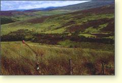
Above: From the Lecht Road, the view is of open, uncompromising moorland.
Tomintoul Distillery
Glenlivet Distillery
Tamnavulin Distillery
Balmenach Distillery
Of interest around Tomintoul
• Tomintoul Museum in the village square has a display on peat-working. There is also a reconstructed farmhouse kitchen with original domestic equipment.
• Tomintoul Peat Moss is worked two miles north of the village and a visitor trail allows access to see how the peat is extracted and the special equipment used.
• Corgarff Castle was built in the 1500s and figured prominently in both the 1715 and the 1745 Rebellions. It became a Hanoverian garrison in 1748 but latterly all there was for the redcoat soldiers to do was help chase whisky smugglers.
• The Speyside Way walking route has a spur that runs between Tomintoul and Ballindalloch, via The Glenlivet Distillery. Bus service allows access to intermediate points and ranger service on the Way provides information.
• Lecht Iron Mine in the hills was worked in the 1730s, the ore being taken over to Nethy Bridge where there was timber for smelting it. The old mine-house is still in place and there is an interpretative display and picnic area.
• An underground Earth House, associated with a Pictish construction, can be seen at Mains of Inverourie. It is a stone-lined granary and dates from about 1200 BC.
• Tomintoul Highland Games take place every year around mid July.
• The Craggan Stones in Strath Avon were used for clandestine open-air preaching when dissenters broke away from the Church of Scotland in 1843. The Free Church (the ‘Wee Free’) was formed as a result. The stones are at an alcove in the fence 300 metres south of Craggan Farm.
• Scalan was a secret seminary for Roman Catholic studies during the 18th century, a period when Catholicism was seen as tantamount to treason. The original house was burned down by Hanoverian troops and the present building dates from 1767.
• Drumin Country Museum displays household and farming equipment illustrating country life in north-east Scotland in the past.